Surigao earthquake damage and assistance
Surigao del Norte, a province in the Caraga region of northeastern Mindanao was the scene of an earthquake with a magnitude of 6.7 that struck on 10 February 2017. The last recorded earthquake in Surigao province occurred more than 130 years ago, in 1873. The epicentre was located near the capital Surigao City. Strong aftershocks that followed prompted residents to leave their homes and head for higher ground. They feared a tsumani would soon follow, despite reassurance local authorities that the tsunami alert had been lifted. According to the National Disaster Risk Reduction and Management Council (NDRRMC), as of 21 February there have been over 200 aftershocks recorded. Many camped outdoors, not wanting to risk staying in buildings including designated evacuation centres.
Over 7,800 people remain displaced by the earthquake. Most of them are staying in open areas near their homes, or with relatives or friends. There were eight reported deaths, three of which were children and two senior citizens, and 202 injuries.

Credit: OCHA/M. Malang Maboa, Surigao City (13 February 2017) - Makeshift tents line the roadside as villagers camp outdoors on higher ground in fear of a tsunami.
Damage to homes, schools, infrastructure
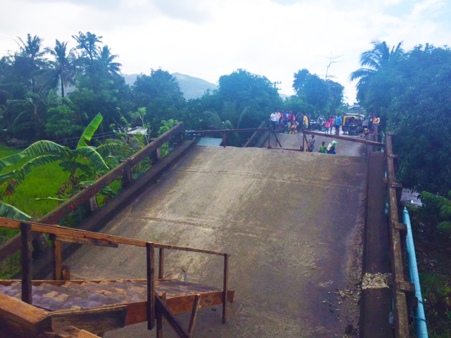
As of 2 March, over 7,200 houses are reported to be damaged, of which 518 were destroyed. About 81 per cent of the damage is located in Surigao City and the neighboring town of San Francisco. Seven bridges are damaged, including Anao-aoan Bridge which collapsed, cutting off San Francisco. Villagers built makeshift stairs out of pieces of wood to cross the bridge, but vehicles have to detour downstream to cross the river. Local authorities are not allowing heavy vehicles to pass bridges which have sustained damage from the earthquake.
More than 40 schools were reported as damaged. A team from the Philippine Institute of Volcanology and Seismology (PHILVOLCS) and geological engineers assessed the structural damage to public buildings, schools, malls and other high-rise buildings. While repairs are ongoing in some schools, on 20 February classes resumed in Surigao City. Several school are holding classes in shifts, while in San Nicolas a church is being used as an alternative school.
Repairs are also prioritized for the Lepata port, which connects Mindanao to the Visayas islands. The ferry service at the port is functional, however access bridges leading to the port have cracks, and heavy trucks are not allowed to enter. Repairs to the Surigao City airport runway are expected to be fully completed in two months. Economic activity and public transport have resumed in Surigao City.
Government action and humanitarian assistance
The priority needs during the first few days of the earthquake were water and shelter materials. While repairs were being made to water systems and broken pipes, the city water district together with the fire protection bureau distributed water to residents using mobile water tankers. As of 16 February, 90 per cent of the af fected population had access to water restored.

Credit: OCHA/M. Malang San Francisco, Surigao del Norte (14 February 2017) - The Anao-aon Bridge split into three places during the earthquake, cutting off access to Surigao City. Vehicles are crossing a river as a detour, which may be impassable during heavy rains.
The Department of Health-Northern Mindanao made mobile treatment facilities available to earthquake affected communities. OCHA met with local authorities and affected communities to help identify immediate and long-term needs. The Office of Civil Defense in Caraga, provincial authorities of Surigao del Norte, Surigao City authorities as well as the municipal government have been responding to the needs of the affected populations. The Caraga Regional Disaster Risk Reduction and Management Office (DRRMO) is leading a comprehensive regional disaster assessment. Local authorities are continuing to survey structural damage to public buildings, schools, and other establishments.
Care, Plan International, World Vision, Action Against Hunger and Habitat for Humanity participated in assessments. Care initially committed internal funds for shelter repair materials, as well as jerry cans and purification tablets. The Philippine Red Cross is providing water, relief goods, medical assistance, and psychosocial support to affected communities.
While there have been no formal requests for international humanitarian assistance, there have been bilateral requests at the local level. Habitat for Humanity has received a request from the National Housing Authority (NHA) for support for shelter materials and non-food items. The Philippines Government has pledged PhP 2 billion (US$ 40 million) for relief and rehabilitation of earthquake affected areas.
The ferry service at the port is functional, however access bridges leading to the port have cracks, and heavy trucks are not allowed to enter. Repairs to the Surigao City airport runway are expected to be fully completed in two months.
Over 29,000 still displaced by flooding in Mindanao
Flooding in low-lying areas in Mindanao is a yearly occurrence, particularly during monsoon season. But from January to February this year, the effects of a low pressure area and the tail-end of a cold front brought unusually heavy rain and flooding in different parts of Mindanao and Visayas. Over 280,000 people have been affected all over Mindanao. As of 2 March, over 29,000 people are still displaced in Caraga region.

Water hyacinth build up in waterways
Aside from heavy rains, the build-up of water hyacinth in rivers and tributaries has further clogged central Mindanao rivers. This is not the first time the plants have wreaked havoc in the region’s waterways.
In 2011, more than 16 hectares of water hyacinth blocked river waterways, causing the riverbanks to overflow and inundate nearby villages. The flooding affected over 770,000 people. To avoid the same disaster, provincial and municipal authorities, with support from the region, are assisting affected populations to mitigate disaster the threat. OCHA visited Datu Piang on 8 February upon the invitation of the Autonomous Region of Muslim Mindanao’s Humanitarian Emergency Response Team (ARMM-HEART) to join them in efforts to clear the river build-up in Datu Piang. The regional government of ARMM is supporting local authorities to remove water hyacinth along Sahid Piang Bridge in Datu Piang.
The municipality is employing the spirit of bayanihan (community volunteerism) to remove water hyacinth from major rivers. Local authorities are working together with the military, ARMM, concerned local groups and villagers, using improvised tools and chainsaws to cut down the plants and ease the blockage. The municipal mayor of Datu Piang cited that while his team has been manually removing the plants, they are overwhelmed by the fast regrowth and would need bigger machinery to completely remove them. With the calamity fund depleted, the municipality has acknowledged that they need the support of the region to find a long-term solution.
OCHA updated the Mindanao Humanitarian Team and is coordinating with authorities to provide assistance on a local level.
Lessons learned from Caraga region flooding
In Agusan del Norte, the low-lying Las Nieves, Santiago, Remedios T. Romualdez (RTR), Kitcharao and Jabonga municipalities are prone to flooding during the rainy season, especially from December to February. The Colorado River and other tributaries drain into these municipalities, making them prone to flooding. Tropical Storm Lingling (locally known Tropical Depression Agaton) in 2014 affected much of this area, overwhelming their local response capacities.
During Tropical Depression Auring in January this year, the province activated local disaster and emergency response teams. They deployed rapid damage assessment teams on 9 January. The prompt response and coordinated actions from the province to municipalities aided them in saving lives and led to faster recovery of the affected populations.
The municipality of Jabonga, Agusan del Norte was one of the affected areas where evacuees sought shelter in a school on 12 January 2017. Jabonga has 15 barangays, of which three of these located along the river were affected by flooding, namely, Barangay Bunga, Colorado and Poblacion. Around 439 families or 1,883 people were displaced. Local authorities activated their command center and monitored the water level of Lake Mainit, as well the barangays with landslide areas.
Best practices during evacuation
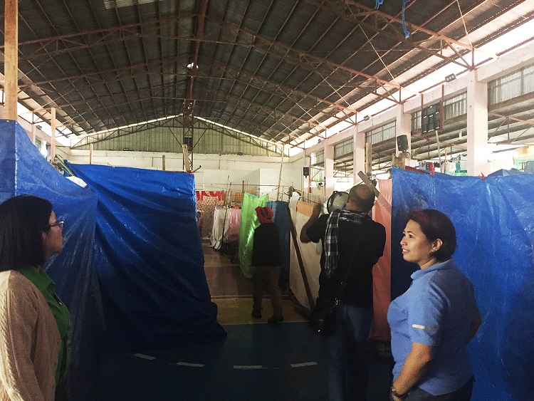
Learning from past emergencies, the local authorities and communities assisted communities during the critical hours before the storm and met their needs in the aftermath of the disaster. Designated evacuation centres (ECs) during Mindanao floodings were mostly the municipal gymnasium or the multipurpose hall of a school. In these ECs, the displaced families put up makeshift partitions to give some level of privacy and protection. The evacuees formed committees to look after their well-being. Families were assigned specific days as sweepers to maintain cleanliness of common sanitation areas. Local authorities have prelisted vulnerable families living in flood-prone areas, which facilitated the easy-tracking of evacuees.

Locals cope with repeated flooding
Liza Yubos fled her home during the flooding with her family. A member of the Mamanwa tribe, she observes that despite the repeated experience of flooding, this was the only time they decided to evacuate. While she missed the comforts of home, she feels safe at the evacuation centre. “We only evacuated now because the water level was too high. My husband still goes back to our area to look for wood to sell. But we are fine here in multi-purpose hall.”
Erna R. Suyo, the Provincial Disaster Risk Reduction and Management officer (PDRRMO) of Agusan del Norte attributes some level of their success to coordinating with leaders at the provincial level. Enhancing the capacity of local government as first responders was critical, she saidR. The local authorities also made good use of their disaster fund by launching preparedness and response programmes.
Relocation options for flood-prone communities
A plan to relocate communities living in flood-prone areas is still in the pipeline. Local authorities have purchased two hectares of land as a relocation site. They also have an agreement with some residents to accommodate evacuees during disasters. They have also tapped the private sector and local business community for disaster preparedness and response.
The municipal mayor of Datu Piang cited that while his team has been manually removing the plants, they are overwhelmed by the fast regrowth and would need bigger machinery to completely remove them. With the calamity fund depleted, they acknowledge that they need support.
A plan to relocate communities living in flood-prone areas is still in the pipeline. Local authorities have purchased two hectares of land as a relocation site. They also have an agreement with some residents to accommodate evacuees during disasters.
Continued conflict heightens displacement in Butig
In January 2017 renewed conflict between the Philippine military and the Maute group, a non-state armed organization, erupted causing further destruction and displacement. The military’s air bombardment and ground shelling affected residents in the Butig municipality of Lanao del Sur province. An estimated 6,000 people were displaced. This conflict started in February 2016, when an armed group believed to be Maute raided the 51st Infantry Battalion of the Philippine Army in Butig. The conflict displaced the local population of about 19,000. They sought refuge with relatives in other municipalities and in Marawi City. By December 2016, 70 per cent of the population had returned from the 13 barangays out of the 16 barangays of the municipality. However, the armed group continued to frequent three municipalities; Poctan, Sandab and Ragayan which have been the main focus of the military.

The Maute group’s recruitment of youth
The Maute armed group is allegedly formed by the Maute brothers in Butig, Lanao Del Sur. The group has reportedly declared allegiance to the terrorist group Islamic State of Iraq and the Levant (ISIL). The move was seen as a symbolic declaration to raise the profile of their struggle and attracting young men and women to join. According to local reports, the group is said to be recruiting youth to join them. The impulse to join these emerging armed groups is likely fuelled by dissatisfaction with the slow progress of the peace process between the government and the Moro Islamic Liberation Front (MILF).
Local leaders are concerned that youth radicalization is an emerging problem that needs to be countered. The local government of Butig and Marawi City conducted series of Islamic symposia to impart knowledge and understanding about Islam.
Response from ARMM and provincial disaster management authorities
Butig is located 60 kilometres from Marawi City, where most of the displaced sought refuge with their relatives. A national high school, health centre, madrasah, mosque and an estimated 200 houses were destroyed by the latest conflict. According to the mayor, people need food, core relief items, farming support and rehabilitation of damaged infrastructure. ARMM’s social welfare, humanitarian and civil defence agencies are working together with regional and provincial disaster management authorities to provide immediate needs of displaced families.
The education of children is greatly affected as they are forced to continue classes in the nearby municipalities. The Department of Education-ARMM set up an Alternative Delivery Mode teaching programme while schools are not operational. The Butig community has been dependent on an irrigation scheme as the main source of livelihood. However, since last year the water distribution system is not operational due to a damaged canal. This is affecting farmlands and food security in the municipality.
Humanitarian Presence in Butig
Several UN and humanitarian agencies are operating in Butig. The World Food Programme is providing nutrition and livelihood support in the five municipalities of Lanao del Sur including Butig while Nonviolent Peaceforce is working in protection monitoring.
The Autonomous Region of Muslim Mindanao’s Humanitarian and Emergency Response Team (ARMM-HEART) plans to conduct an inter-agency assessment with the Mindanao Humanitarian Team in order to have a complete assessment and analysis of the impact of the conflict in terms of humanitarian and early recovery needs of affected communities.
According to the Mayor, the people need food, core relief items, farming support and rehabilitation of damaged infrastructure. ARMM’s social welfare, humanitarian and civil defence agencies are working together with regional and provincial disaster management authorities to provide immediate needs of displaced families.
Philippine delegates attend Humanitarian Partnerships Networking Week
A multitude of colorful balloons marked the opening plenary session of the Humanitarian Networking and Partnerships Week (HNPW), held in Geneva 6-10 February. Hosted by the Swiss Government and co-chaired by the UK's Department for International Development and the UN Office for the Coordination of Humanitarian Affairs (OCHA), the HNPW provided an opportunity for experts, government representatives and humanitarian responders to discuss common challenges and explore innovative solutions.
The balloons were used to signify the constellation working groups and problem-solving sessions held during the event, ranging from civil-military coordination to the experience of cash-based assistance in different crisis settings. Building on the World Humanitarian Summit of May 2016, the over riding message of the week was that of localization, making the response as local as possible, international as necessary.

Philippine Government and private sector participation
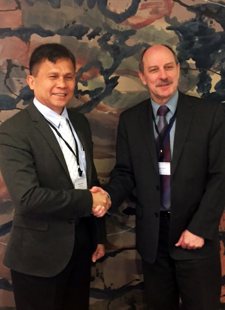
The Government of the Philippines played an active part in the proceedings, with a delegation led by the administrator of the Office for Civil Defense, Undersecretary Ricardo Jalad that included senior representatives of the Armed Forces, the Department of Social Welfare and Development (DSWD) and the Department of Finance. Butch Meily, President of the Philippines Disaster Resilience Foundation (PDRF), brought the perspective of the private sector.
The focus for the Philippines was on its future engagement with the UN Disaster Assessment and Coordination (UNDAC) mechanism, next steps in the country's determination to build national capacity for urban search and rescue by drawing on the support of regional members of the International Search and Rescue Advisory Group (INSARAG), and in developing national guidelines for civil-military coordination, a commitment under the Asia-Pacific Regional Consultative Group (RCG) on humanitarian civil-military coordination, where the Philippines was the founding chair in 2016 and a continuing active member.

The changing humanitarian landscape and building strategic partnerships with the private sector figured in a number of the thematic working groups, reflecting a shift to a more holistic approach to disaster risk reduction, emergency preparedness, response and recovery. This found particular focus in the first annual meeting of the Connecting Businesses initiative (CBi) and where the experience of the Philippines in partnering with private sector networks in Fiji and Myanmar was showcased.
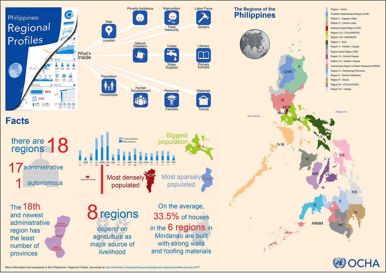
Each snapshot contains a national or regional map and visual representations of regional demography, poverty and human development, disaster statistics and sectoral information on nutrition, water, sanitation and hygiene, health, livelihood, education and shelter.
In brief: launch of Philippine Regional Profiles, a compilation of vital data for disaster preparedness
The United Nations Office for the Coordination of Humanitarian Affairs (OCHA) in the Philippines released the newly updated Philippine Regional Profiles, a compilation of geographic and demographic data of the 18 regions of the Philippines. Each snapshot contains a national or regional map and visual representations of regional demography, poverty and human development, disaster statistics and sectoral information on nutrition, water, sanitation and hygiene, health, livelihood, education and shelter.
Data from the profiles were gathered from various sources such as the Department of Education, Department of Health (DOH), Department of Social Welfare and Development (DSWD), Food and Nutrition Research Institute, National Disaster Risk Reduction and Management Council (NDRRMC), Philippine Statistics Authority (PSA) and the Office of Civil Defense (OCD).
Each snapshot contains a national or regional map and visual representations of regional demography, poverty and human development, disaster statistics and sectoral information on nutrition, water, sanitation and hygiene, health, livelihood, education and shelter.
